Friday, May 31, 2013

A lot can happen in a week...


The Hudson-Mohawk Bird Club conducted an overnight field trip to Perch River WMA near Watertown, NY on Sat., May 25th- Sun., May 26th. We escaped rainy, windy, very cool weather in the Capital District, but the conditions were only marginally better at our destination. At least there was no rain. Some of the participants stopped at Tug Hill WMA southwest of Lowville in Lewis County on the way up Saturday, then moved up to Chaumont Barrens Preserve early in the afternoon.

It was windy and cool at Tug Hill WMA. We were hoping to see some of the woodland songbirds and warblers that breed on the plateau, but the birds had other ideas. Chestnut-sided Warbler put in an appearance, but only a few other species could be heard in the distance. Mourning Warbler, our target species, which usually can be easily observed there, was absent. We decided to leave early and devote more time at our other two Day One stops.


65 acre impoundment at Tug Hill Wildlife Management Area (click to enlarge)


 active Osprey nest on Morris Tract Rd., Chaumont (click to enlarge)


Chaumont Barrens Preserve is one of the last and finest examples of alvar grasslands in the world, and is a link in the chain of North American alvars forming an arc from Jefferson County through Ontario, and all the way to northern Michigan.


Chaumont Barrens Preserve, protected by The Nature Conservancy (click to enlarge)


The soil layer is very thin, covering limestone underneath, which is exposed in places. Many of the plants are unique to this habitat, and others are stunted versions of species seen elsewhere, especially the evergreens.


trail at Chaumont Barrens (click to enlarge)


It was early afternoon, so things were fairly quiet at the Barrens, but we saw singing Great Crested Flycatchers, Field Sparrow, an Eastern Kingbird, a Brown Thrasher, and a handsome Black-and-white Warbler. We could also hear our target species, Golden-winged Warbler, in two different places, but they remained out of sight range.

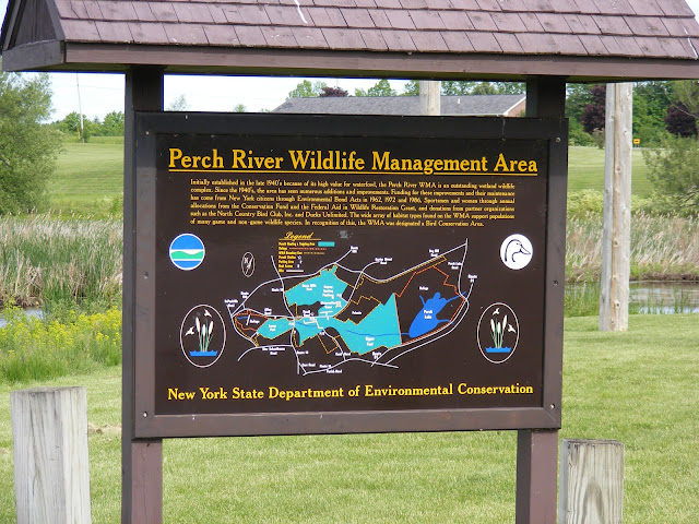
We met the other members of our group at Perch River WMA, which is located about eight miles to the northwest of Watertown. It is some 8,000 acres of high quality wetlands bordered by deciduous forest, shrubland, and open agricultural fields.


 main parking area at Perch River WMA along Rt. 12 (click to enlarge)


 Caspian Tern flyby (click to enlarge)


We birded Perch River for two hours Saturday afternoon, and for three hours the next morning. Highlights included three American Bitterns in the grassy field below the observation tower near the Stone Mills Pool, Black-crowned Night-Herons, Pied-billed Grebes, many Osprey, a Wilson's Snipe, Caspian Terns, and many Black Terns flying back and forth between the Upper and Lower Pools.


 Perch River map, including the refuge areas (click to enlarge)


 view of the Upper Pool, Perch River WMA (click to enlarge)


 view of the Lower Pool at Perch River WMA (click to enlarge)


 Marsh Wren foraging just above the water (click to enlarge)


 Black Tern soaring above the Lower Pool (click to enlarge)


On Sunday afternoon, a few of the participants returned to Chaumont Barrens to attempt to visually observe the Golden-winged Warblers. After ninety minutes of moving back-and-forth, to-and-fro, here-to-there-and-back, we finally nabbed the little bugger. Getting a good visual can be important with winged-warblers, as the two species can interbreed and produce variably plumaged and voiced offspring.


 information kiosk at Chaumont Barrens (click to enlarge)


 limestone fissure, watch your step (click to enlarge)


cephalopod fossil in limestone (click to enlarge)


 Alvar landscape (click to enlarge)


 Prairie Smoke and grasses (click to enlarge)


 Chaumont Barrens (click to enlarge)


 Golden-winged Warbler behind branch (click to enlarge)


Golden-winged Warbler behind pine needles, center (click to enlarge)


Field of Prairie Smoke at Chaumont Barrens Preserve (click to enlarge)


TW

Thursday, May 23, 2013

Partridge Run WMA & Huyck Preserve


Partridge Run Wildlife Management Area is located in the Town of Berne in western Albany County. It consists off about 4500 acres of upland and wetland habitat. There are many places to park along the roads through the area, and trails to hike on. Partridge Run hosts a wide variety of wood warblers, thrushes, and flycatchers. Some of the best birding can be done along Kingfisher Rd., which dead-ends at Partridge Run Rd. along the Switzkill.


 Switzkill at Partridge Run Rd. & Kingfisher Rd. (click to enlarge)


 Eastern Wood-Pewee, Partridge Run WMA (click to enlarge)


 male American Redstart, Kingfisher Rd. (click to enlarge)


 Eastern Wood-Pewee, Kingfisher Rd. (click to enlarge)


 Main parking area at Ravine Rd. and Sickle Hill Rd. (click to enlarge)


 trail to Pickerel Pond, Partridge Run WMA (click to enlarge)


Pickerel Pond, Partridge Run WMA (click to enlarge)


 beaver pond, Partridge Run WMA (click to enlarge)


 Least Flycatcher at beaver pond (click to enlarge)


 Wood Duck Pond, Partridge Run WMA (click to enlarge)


The Edmund Niles Huyck Preserve and Biological Research Station, located in the beautiful hill country southwest of Albany, N.Y., is a mecca for researchers, educators, and people seeking peace and serenity away from the pressures of modern life. The Preserve is part of a vast tract of land, or "wyck," established in 1629 by Kilian van Rensselaer through a charter from the Dutch West Indies Company and subdivided in 1785 by Stephen van Rensselaer, eighth patroon of the manor. Rensselaerville became a bustling village after the Revolutionary War. Edmund Niles Huyck, for whom the Preserve is named , was the son of the founder of a felt mill established at Rensselaerville in 1870. Its remains still are visible near the foot of the Rensselaerville Falls. After E.N. Huyck died in 1930, his widow, Jessie Van Antwerp Huyck, and other heirs established the Preserve. Above all else, this natural resource is a refuge for nature - a place to be left unspoiled and undeveloped. The original charter of the Preserve states that its purpose is "to preserve the natural beauty of the Rensselaerville Falls, Lake Myosotis, Lincoln Pond and the land around them...and to increase the general knowledge and love of nature." ** (http://www.huyckpreserve.org/about/history.htm)


 Huyck Preserve, Rensselaerville (click to enlarge)


 Myosotis Lake, Huyck Preserve (click to enlarge)


 female Chestnut-sided Warbler, jumping around at nest site (click to enlarge)


 Alder Flycatcher, eastern Lake Trail at Huyck Preserve (click to enlarge)


 eastern Lake Trail at Huyck Preserve (click to enlarge)


 Myosotis Lake, Huyck Preserve (click to enlarge)


TW

Wednesday, May 22, 2013

A great deal of company...


"You only need sit still long enough in some attractive spot in the woods that all its inhabitants may exhibit themselves to you by turns."- Henry David Thoreau in Walden


Indigo Bunting, Malta Tech Park (click to enlarge)


 Willow Flycatcher, Normanskill Farm (click to enlarge)


 Willow Flycatcher singing "fitz-bew", Normanskill Farm (click to enlarge)


 Nature trail, Thacher Park, Hop Field (click to enlarge)


 Boardwalk, Thacher Park, Hop Field (click to enlarge)


 Blackburnian Warbler, Thacher Park (click to enlarge)


 Thacher Park, Hop Field trail entrance (click to enlarge)


Bennett Hill Preserve, Clarksville (click to enlarge)


 female Northern Parula, Albany Pine Bush- Karner Barrens East (click to enlarge)


 female Scarlet Tanager, Albany Pine Bush- Karner Barrens East (click to enlarge)


Wild Lupines and Pitch Pines, Albany Pine Bush (click to enlarge)


male Orchard Oriole, Normanskill Farm (click to enlarge)


TW

Sunday, May 19, 2013

Sterling Forest State Park and Doodletown


On Thursday, myself and two other area birders ventured down the Thruway to Rockland and Orange Counties, where we met up with a local resident to explore Sterling Forest State Park, and Doodletown.

At the end of Ironwood Rd. in Sterling Forest SP, the cul-de-sac intersects a power line cut that allows access to the Sterling Valley Loop trail. It is at this location that a distinct population of Golden-winged Warblers exists, side-by-side with its Blue-winged relatives. It is also good habitat for Indigo Bunting and Prairie Warbler, and the nearby woodlands host both Hooded and Cerulean Warblers.

We were able to hear two Golden-winged Warblers, but it is always desirable to see the singing bird to eliminate the possibility of a hybrid, or a bird that sings the "wrong" song. Here is some fascinating information on the subject.

We spent about an hour in the area, and came up with this species list.


Cul-de-sac at Ironwood Dr. power line cut (click to enlarge)


Trail access at Ironwood Dr. (click to enlarge)


 Indigo Bunting, Ironwood Dr. (click to enlarge)


Doodletown is one of the premier spots in the Hudson Valley to observe transient and resident migrants; it is teeming with Hooded, Cerulean, and a few Worm-eating Warblers each spring, birds that are hard to come by just a bit farther north in the Capital District region. But what's with the funny name?

Doodletown (excerpted from Wikipedia):

Doodletown was first settled in 1762, at least partly by descendants of French Huguenots. The name is said to derive from the Dutch for "dead valley", or Dood Dal, with the "town" suffix added later by English-speaking settlers. Early residents worked as loggers and miners, and the remains of the mines are still visible today. There were also small farms and businesses.

The settlement was a crossroads for soldiers during the Revolutionary War during battles at Bear Mountain's Fort Montgomery when many hundreds of British soldiers marched through the tiny settlement prior to a bloody and significant battle with colonists.

In the 1890s, Thomas Edison bought a defunct iron mine in Doodletown to test his proposed technique for an improved method of refining ore. Nothing came of his project, although several iron mines had been successfully developed and abandoned in the neighborhood at a much earlier date.

Bear Mountain began to be developed as a park in the early 20th century. By the 1920s, the height of population for Doodletown, the settlement had a school, a church, several small businesses, two cemeteries and approximately 70 homes. At least several families had lived there for generations. Around this era, military and tourism-related enterprises on nearby Iona Island employed residents, as did the Palisades Interstate Park Commission.

Other residences were maintained as second homes or were inhabited by retired people from the New York City area, and Doodletown's population thus reached its historic peak of hundreds of residents. Bear Mountain State Park began to expand around 1920, in part by purchasing property from the landowners in Doodletown. By the 1950s, most of the Doodletown residents had moved away, many to nearby Stony Point or into southern Orange County. Those who refused to sell lost their land through eminent domain by 1965, and most of the remaining structures were demolished or disassembled and moved out by the late 1960s. Debris was buried, the roads were closed, and the surrounding woods were allowed to grow over the properties. In the early 1970s, a dam was built on the Timp Brook, creating a sizable pond. The last remaining building, the stone school house, was kept as a shelter for hikers until vandalism caused the park commission to tear it down in 1980.


Doodletown map (click to enlarge)


Doodletown rises up the west side of Rt. 9W//202 across from the Hudson River. On the east side is the Iona Island Bird Sanctuary.


View from the bottom of the Doodletown trail (click to enlarge)


Iona Island (click to enlarge)


Iona Island (click to enlarge)


Hudson River estuary at Iona Island (click to enlarge)


Along the 1777 trail at Doodletown (click to enlarge)


We observed many Hooded and Cerulean Warblers, and even heard a White-eyed Vireo, which is uncommon to rare north of the New York City region. But the highlight for me was a migrant Olive-sided Flycatcher, singing his "quick, three beers" song from the top of a snag.


Olive-sided Flycatcher, Doodletown (click to enlarge)


Later, we found him on our descent on a different dead snag...


Olive-sided Flycatcher, Doodletown (click to enlarge)


Trail down Gray's Hill... (click to enlarge)


Looking back up the hill... (click to enlarge)


View to the south of Dunderberg Mountain (click to enlarge)


TW